Crossing of the Western Hajar, Oman
- Marine Med
- Dec 11, 2020
- 15 min read
Updated: Nov 6, 2022

6 days of hiking across the Western Hajar Mountains in Oman in January 2019
147 km from Izki to Al Hamra
Via the Persian steps and the track of the UTMB Oman 2018
GPX traces
The GPS trace recreated from the recorded data of my Garmin watch can be downloaded here ici.


What bring me there ? How did we determine our route ?
Attracted by the Middle East, I had already spotted Oman as a very interesting and rising destination but without already having the opportunity to take more interest in it.
A plan to go hiking with a friend at the end of January made me look for countries with a suitable climate in winter.
That's when I found Simon's article on i-trekings (in french). He crossed by foot the Western Hajar.
The idea to go in Oman hiking in the montains but also in the desert was there!
And we quickly agreed with my friend.
Then, I did more research to have traces, more information, ...
This is how I found the UTMB trace from November 2018, official maps, ...
With all those sources of informations but also with the Bradt travel guide Oman, 4th edition (very good travel book edition), we estimated being able to manage on the spot.
Here the usefull links to find informations:
Link to all infomations about the UTMB Oman 2018 here.
The race of November 2019 had a 170 km going to the Jabal Sham from the "Col Trail Split".
By reading the Simon's story on i-trekking, it did not seem possible to us to go directly to the Jaba Sham from the route we were following.
Locals we met the last day of our walk (see here under) seemed to tell us that it was indeed impossible.
I am so curious of what the UTMB found/created as a track to go to there and exend the course! Find more info about that on the UTMB Oman 2019 website. Very interesting for even more hiking in the future! :D
Another important source of informations on the available trails is the official website OmanTourism that compiles maps of existing trails and those that are marked.
The marked trails are not the easier that we have seen and the marks were not always easy to find.
On the unmarked trails, really do not expect much.
And so, our first source of inspiration: Simon's article on the website itrekking. Simon describes very well his crossing, but it is in French.
Choice of departure
By analysing the information that we had found, I realised that we had 3 options to start the hike:
via the wadi Halfayn like on itrekking
via Imti as explained in the Bradt and via the Persian steps (W22 of the OmanTourism map)
via Birkat Al Mawz and the wadi Al Muaydin following directly the UTMB trace
The description of the Bradt made me want to start with the Persian steps. It also allowed us to take a bus easily to Izki and to cross a larger part of the villages of the Sayq plateau and in particular to have the opportunity to walk the Village walk.
So, we made this choice which made us start our own adventure with the Bradt as the only source of information.
Day 1
From Izki to somewhere along the Persian Steps
16,3 km - 1300 m vertical drop - 5h
Arrived at night at Muscat airport, we waited for the first bus to go to Izki.
From the aiport, there are direct buses to Nizwa that stop at Izki.
By taking our tickets on the bus, it costs us 1.25 OR per person.
The journey took about 1 hour 30 minutes.
Arrived in Izki before 8 am, our first thing to do was to find something to eat as a breakfast but especially for our first days of hiking.
So, we found stores that had just opened for our shopping.
We did not find a gas bottle compatible with our stove so we just bought bread (a kind of pancakes in fact, very thin), almonds and other dried fruits, peanut butter, cookies, bananas, La Vache qui Rit cheese, canned hummus, cucumbers, ... and of course a lot of water. Our first refueling was to take 3 bottles of 1.5l each plus a large one of Coke. The purchase of the Coke bottle was useful in order to eventually be able to use later the filter that we had with us.
The bakery allowed us to take breakfast and bread. We also had a cup of tea. Be careful, we were surprised that it was served to us with milk without asking for it.
With all the shopping done and our stomachs full, we were ready to start walking! :D

First we followed the road, that we had already taken by bus, between Izki and Imti. From there, we were able to follow the indications from the Bradt (OmanTourism W22 path).
So we left the entrance to the village towards the mountains. There we came across, as expected, the ancient Persian village. We approached the ruins to browse them.

We then went to the garden (or the oasis). We decided to sit there to eat and drink something.
A man then arrived. He came to work in the palm trees. We chatted with him and he showed us how he climbs the tree to "inseminate" the female palm.
Impressive!
And very nice! He invited us to eat at his house later but we wanted to continue our journey.


We continued until leaving the village, to follow a road that led us to a dam.

At this point, we headed towards the left Wadi, the one that leads to the Persian steps.
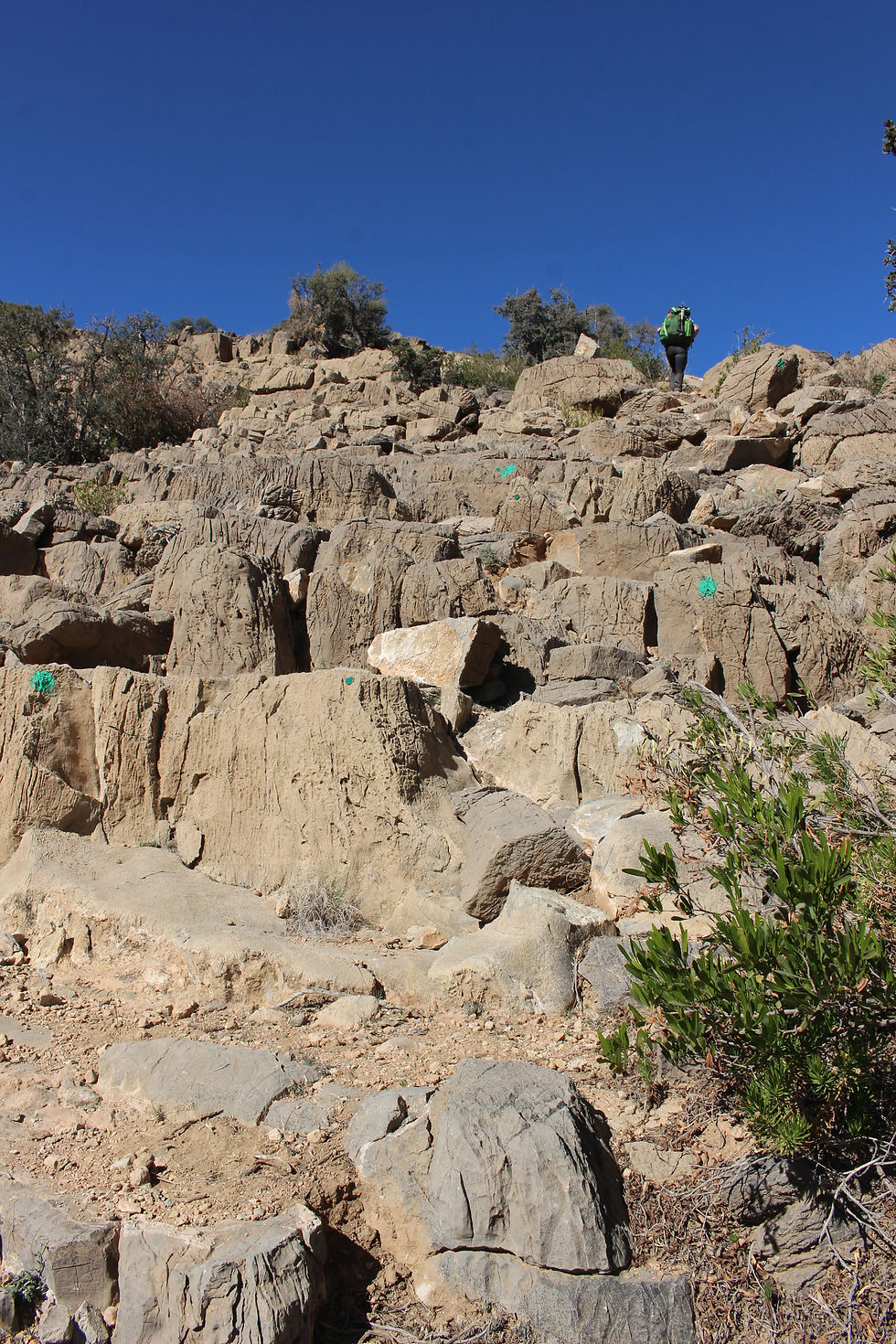
We hesitated for a long time to know if we were on the right path because at the beginning the path was really not clear and we had to make our way among big rocks. But we were right to persevere! We finally arrived at the foot of the Persian Steps! Ready for the way up!

1400 steps walks according to the Bradt! But impossible to count in reality! The "steps" being very irregular and not always present.
It goes up well! We are moving slowly. And the afternoon is going well!
The steps are not too complicated to follow but it is still possible to lose the way. You have to stay alert when the road turns. We left the path at one point but the direction was easy to find: we had to go up! We were able to find the steps again because the ground next to it was not very stable in some places and I did not feel confortable there.

We tought we could get to the top of the steps at once but no, it's not a continuous staircase, it's whole climb with different parts, and we could not have reached the road before the night.
So we decided to find a place to set up our camp for the night.
The view was wonderful! But it quickly got dark!

Day 2
From somewhere along the Persian Steps to beyond the villages of the Sayq plateau
27,4 km - 1107 m vertical drop - 7h
Wake up under a wonderful sunrise!

We start back on the Persian steps.
In one place, we felt it was not going to pass but once we got there, the path was quite passable.

We walked for a while before getting at the road that leads to the Sayq plateau.

Arrived at the road, we tried to find a path, which according to the maps of OmanTourism allows to cut shorter but we did not find it so we decided to walk along the road.
The road is very recent, and in very good condition. In some sections, concrete parapets obscure the view on the valleys.
This part is not the most beautiful part of the trail, but it still allows to have the feeling to move forward because at least the terrain is not as difficult as it was on the previous parts.
When we reached the entrance of the villages, we decided to take a detour through the heart of the village of Al Aqar to try to fond something to supply us.
We even saw on Google Maps that there were restaurants when the Bradt said there was only a small shop, which opened sporadically. Obviously, this information was not longer up to date, since we found a small indian restaurant to eat and then a store for supplies.
We came across a lot of construction sites in the villages. Obviously, the new road has made this more accessible and everything is developing rapidly.
We therefore took a long break before setting out again along the villages, above the terraces, for a mire touristic walk, with a superb view of the local cultures (W18b OmanTourism).

On this part, we met some tourists.
At the exit of the villages, we found the trace of the UTMB Oman.
So we ended our day by following this trail. We were happy to have a clear path to follow and not to have to find ou way anymore.

Night came quickly so we looked for a place to pitch our tent.
We found, in a fairly flat area. The villages were not far away, but enough not to disturb and be disturbed.
We were between As Sayq and Al Ala.
Day 3
From beyond the villages of the Sayq plateau to somewhere above the Wadi Tanuf
27 km - 1260 m vertical drop - 7h15

3rd day of walking, we gently followed the trail of the UTMB. We quickly arrived in Bani Habib. We enjoyed a beautiful view on the valley and the village.
The trail took us down to the abandonned village. We went through it. Everything there was like frozen.

We then came out of the wadi where the village was located and we landed on a dirt road.
We followed it for a while, it rested our legs after all the rocks from the start of the day.


We followed this road to a small village.
We thought we might find water there, but we did not see any minarets that indicate a mosque.
We saw a few inhabitants there, but who remained very discrete.

We hesitated a bit on the way to go out of this village, but we had to go down, towards the ruined village which is a little lower.
We went down a bit as best we could do and then we found our dear green marking at the exit of the ruins.

We then descended a little lower. We then found ourselves a place with a clear view on the Wadi to take a lunch break.
The menu had not changed much since the start of our walk: bread, Vache-qui-rit, almonds, ...

We then went up this Wadi to find ourselves on the other side with a superb view!

We then continued on the ridge until another expectional view on the Wadi Tanuf.

We then moved away from this point of view to bypas the Wadi. At the end, we made a slight detour to go to a village where we found a mosque to supply us with water.

We just ran into a man at the mosque who also offered us to use the toilet. We then understood that he was the muezzin because the call to pray was launched after leaving us.
Refueled, we found our trail to continue a bit longer.
Another cookie break during which we met a local runner. So there are some locals who train to run on these grounds. We chatted for a few minutes.
He was able to gives us directions to the next villages where we could find food. Nothing directly on our route. We were therefore going to make a detour or to hitchhike a bit to not have to walk too long on roads.
We continued for a bit before trying to find a suitable place to pitch our tente.


We found, still along the wadi, thank to what we enjoyed again a wonderful views onder the light of the sunset.
Day 4
From somewhere above the Wadi Tanuf to a bit further than Ar Rus
22,7 km - 1700 m vertical drop - 6h00

Sunrise along the wadi.
We started by following the crete, to finally almost turn around and start again in another valley.
We then began a descent, the we climbed, before desceding into a deep wadi.
To reach a village, it was then necessary to go up on a rather difficult path.


We then found the small village, inhabited, and an asphalt road.
According to th indications received the day before, there is no store in this village, which must be Al Hilaylat.
We met a whole group of young men who seemed to come out of the mosque and we had a chat with them.
We asked them if we could find food and where we could find it on our way to Bilad Sayt.
they said we were not going to find anything in Bilad Sayt either.
They came to suggest to take us by car to a village where there is a store.
We accepted, while lowering the price they asked us. 15 OR was already a lot.
Here we took our beautiful car, which we really feared to get dirty.
When we got to the village, the stores was not open, so they started looking fot the owner to open for us.
He came quite quickly. So we did our shopping even though there really was not much in the store.
And there was no bread.
We then asked where we could find it and there was obviously a place on the road back to the village where we were going to stop.
It was actually a snack bar along the road selling food.
We just asked to bake bread for us, but the guy of the place was surprised when we asked 20 pieces. We agreed on 10 and then we waited a good half hour.
We spend time chatting with our drivers, who offered us other little things to eat and drink.
Finally, after another tea, our breads were ready and it seemed there were well 20.
They looked so good, real pancakes, very fresh, excellent!
Return to the village to resume our journey.
After thanking our drivers, we stopped for 5 minutes to enjoy a crepe with nutella! Too good!

Then we resumed ou way, along the road. We decided to follow it and cut the two loops of the UTMB track which on one side did not seem to take us to nice places and on the other side make us descend steeply into the wadi.
So we followed the road to Ar Rus.
We passed by a luxury hotel, where we wondered if we could have found food there.
But we did well not to count on it! It is very fancy and the rooms were very expensive!


After Ar Rus, we found the trail back (UTMB trace which follow W10). We continued a bit but it was getting late.
We struggled to find a place to pitch our tent. Finally we found a very small place but it was almost on the way.
As we had not better, we settled there.
We were awakened during the night by donkeys! They were visibly annoyed that we were so close to their path.
Indeed, many of the paths we used are in fact donkeys paths. They are the ones who borrow them the most and who maintain them someway.
Day 5
From a bit further than Ar Rus to the campsite halfway up above village of Bilad Sayt
27,9 km - 1634 m vertical drop - 7h30
We decided to wake up early in order to dismantle our camp quickly and not disturb anyone. We still met two young Omani during our tidying up.

We started the day with a descent then we went back up, with wonderful landscapes. We made a short detour from the trail to climb to a summit from which we had a beautiful view on the Jabal Sham and where we had a great photo shoot.

We then continued on our way to reach an asphalt road between two valleys. Nice views on both sides and a place to sit down for a bit to take time to eat something.
Here, we met a lot a other tourists with cars and also goats. They were very interest to share ou dinner with us.


From there, we followed the dirt road to Hat and then Bilad Sayt. A long descent where the ground was quite slippery and very dusty.
Lots of cars went by, in both directions and the views were amazing.
The tourists cars were very friendly and often stopped by our side to chat with us and ask if we needed anything.
One of the guides insisted on giving us cold bottles of water! It was good to drink it!

We also met a French cyclist coming up the road. We took time to discuss his cycling route with him. He was very brave to go up this road by bike.


We went down to Hat then to another small village.
There, we entered a canyon at the entrance of which we found a water point, very dirty.

We crossed this canyon and realized, once we got to Bilad Sayt, that is was a shortcut to cut the road between the two villages.

So we arrived at Bilad Sayt where we met other tourists, including a group of French tourists with a French speaking Omani guide.
They also insisted on giving us water then the guide had indicated us the mosque for supplies.
We were also directed to stores, which were closed.
We had enough to eat so we did not try to open the stores for us.
We filled up with water at the mosque and then we went to visit the fortress of the village.
Bilad Sayt was really very pretty, a real oasis of life.
After a few days in the mountains, we found a bit of contact with locals here.

After visiting the fortress, we decided to continue on our way because we had to make the great ascent above the village (W8 path, marked).
1000 m of elevation gain in a few kilometers. Suffice to say that it was going to climb hard.
As we left the village, some children followed us, insisted we take pictures and even try to use our cameras.
Once past their football field, we took one last short break before starting the climb.
We met two young Omani there who where going to jog the ascent.
Just like the guide earlier, they told us that there were possibilities to pitch our tent in the ascent and a large space (up to 10 tents) halfway up.
We were therefore reassured, because we did not have time to climb to the top before sunset.

The ascent was really not easy, and with the backpacks, it was sometimes necessary to help ourselves with our hands.
But the view over the village and the valley was amazing!
You should not be cold-eyed for certain passages!
We really hoped to get to the camp halfway before the dark because this path by night can be dangerous.
We again met our two young joggers who seemed surprises at our rate of ascent.
It is true that we were making good progress.

We saw a few small places where it would have been possible to pitch our tent or sleep under the stars if necessary but very little compared to chat we expected from the locals.
But our timing was perfect and we reached the mid-climb and its large camping space just before dark!
Another very beautiful day on the Omani roads and paths! And more meetings this day.
Day 6
From the campsite hafway up above the village of Bilad Sayt to Al Hamra, via Misfat al Abriyyin
25,9 km - 1183 m vertical drop - 7h

Waking up above Bilad Sayt, photo shoot to enjoy the beautiful morning light and we took back our ascent.

The second part seemed less difficult to us but we were also fresher.

The view was increasingly clear. Once the last 500 meters of vertical drop had passed, we had a short break but it quicky started to climb again.

Shortly after starting our descent to Al Hamra, we encountered a group of local youths getting ready to eat in their little mountain house.
One of them, a policeman, spoke fairly good English and we were able to talk with each other.
We had the opportunity to ask them if they knew the way to go directly from there to Jabal Sham but they did not seem to know.
He invited us to share their meal with them.
So we sat down with them, ate few dates, tasted their coffee and waited for the meal to be ready.

We then al ate with our bare hands in the dish placed on the ground in the center of the circle that we formed.
Fortunately, they had bought us a bowl of water to wash our hands.

Their dish included meat, they reserved a zone of rice without meat for me and cut me some small cucumbers.
These young Omani were very nice, also wanted to try our cameras and did not want to let us go without trying to ride the donkeys!
Something that we did and that amused us a lot!

Our policeman then offered to come down with us.
He wanted us to wait a good hour first, but we explained to him that we still had a long way to go and that we could not wait.
He then decided to go with us anyway.
We therefore resumed the descent in his company.
He was jumping from rock to rock to descent. He really had the local technique. Not always easy to follow with our backpacks! In any case, he will not have slowed us down!
And he also offered us explanations along the way which is always nice to learn more about the place we are visiting.
He also showed us a source of water, drank there while filtering with his scarf, offered some to us but we preferred to abstain to not risk being sick, the water being rather cloudy.
We also met a group of French, expatriate workers, who knew the country and had participated in the organization of the UTMB Oman. We took some time to chat with them.

The descent on the rocks was very tiring. And long.
Before arriving at Misfat al Abriyyin, we took one more short break to eat a bite.

When we arrived at Misfat al Abriyyin, we were happy to see greenery again.
We also very quickly started to meet tourists.
We took the time to chat with two Dutch people.
We felt uncomfortable after 6 days of walking without a shower to be now in the middle of all these tourists.
We took a little tour in Misfat following the trail.
Leaving this green oasis, the two Dutch offered us to take us down to Al Hamra with their car but we wanted to finish by foot.
So we followed the road down into the valley towards the city.
Along the way, we called a hotel (Dar Alhmara 22 OR) found on the internet to book a room and be sure to have one when we arrived!
When we were at Al Hamra, we crossed the end of the UTMB trace.
We then crossed the city by foot, with a short stop to buy a cold drink, to go to our hotel.
The last kilometers were long but we were happy to arrive at the hotel for a good shower, a good restaurant and a good night of sleep after those 6 very beautiful but tiring days crossing the mountains of the Western Hajar!
In Summary ?
A very nice hike! And very few people crossed on the way.
Exceptional views and landscapes!
Hats off to those who ran this UTMB! It is really very physically demanding!
The Western Hajar is a wonderful region to discover!


Comments